Fort Norfolk History - 1816
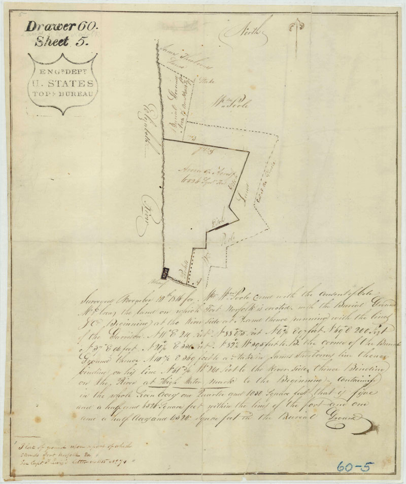
In November 1816, William Poole acknowledged the additional land that the U.S. Army at Fort Norfolk had taken from the family property. Lieutenant Colonel William McRea, the artillery commander at Norfolk harbor, authorized a military surveyor to prepare a plat of the new boundaries (Engineer Department Topographic Bureau [EDTB] Drawer 60, Sheet 5) (see above). While the plat does not depict the fort, it does show several associated features that might prove archaeologically significant. There is no indication that the plat accompanied an actual deed of sale, but the document does state that the survey was conducted at Poole's request. During the War of 1812, camp sickness had apparently necessitated the creation of a burial ground on the north side of Fort Norfolk property. The 1816 plat shows the ditch surrounding the fort as well as pan of the palisade. After the war, a portion of Thayer's palisade may have been removed to provide easier access to the fort proper. The palisade posts were marked as "pickets” just east of the wharf. The plat also indicates that the ditch surrounding the fort marked the property line and that the glacis had been extended onto the Poole property. The hatched line denotes the "foot of the Glacis" (EDTB Drawer 60, Sheet 5) (see above). The burial ground was situated above the northwest comer of the fort between the property of William Poole and James Thorborne. The land within the cemetery took up "one and one half acres and 4524 square feet." The Fort Norfolk property, including the burial ground and glacis, now comprised "Seven acres one Quarter and 1050 square feet," substantially more than the 4.31 acres that the U.S. government had originally purchased from Edward Poole (EDTB Drawer 60, Sheet 5) (see above).
More History
Back, 1673, 1775, 1787, 1789, Army before 1793, 1793, 1794, More 1794, First Fort, 1795, 1796-1800, 1801-1806, 1807, 1808-1811, 1812, 1813, 1813-1814, 1816, 1817-1818, 1820-1821, 1824, 1835, 1842-1844, 1845, 1849, 1851, 1852, 1853, 1854, 1854 Keeper's House, 1854 Changes, 1858, 1859, 1861, 1862, 1863, 1864, 1875, 1884, 1893, 1903, 1923, Next
Source of Information
A CULTURAL RESOURCE MANAGEMENT PLAN OF FORT NORFOLK, NORFOLK, VIRGINIA prepared for U.S. Army Corps of Engineers, Norfolk District by the College Of WILLIAM & MARY, November 1995 under Contract No. DACW65-94-Q-0075.
David A. Clary's Fortress America: The Corps of Engineers, Hampton Roads, and United States Coastal Defense (1990)
William Bradshaw and Julian Tompkins's Fort Norfolk, Then and Now (n.d.).
The Norfolk Public Library vertical file of recent newspaper articles on Fort Norfolk. Including articles by James Melchor of the U.S. Army Corps of Engineers that describe archaeological and architectural findings on the fort property.